
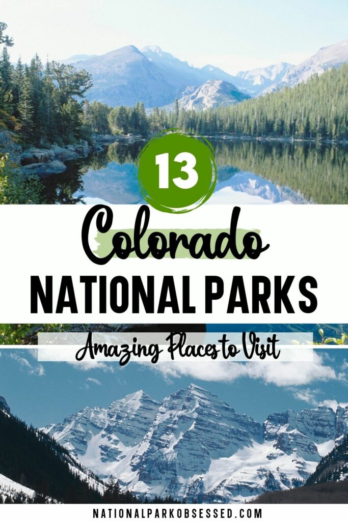
Post Summary: National Parks in Colorado
Known as “Colorful Colorado” for its beautiful landscapes of different canyons, valleys, mountains, plateaus, rivers, and lakes. It is no surprise that Colorado is one of the most visited states for tourists in America. It is known for its gorgeous views and the many natural wonders for travelers to enjoy. From clear waters, gargantuan mountains, to the interesting wildlife native to the area, nature enthusiasts will have a field day here in Colorado.
With the wealth of nature in the state, there also lies a rich history from the Civil War, the commercial trade between the States and Mexico, to as far back as the Eocene era of Dinosaurs. Colorado definitely boasts so many worthwhile destinations in its 16 national parks. Let’s start exploring the National Parks in Colorado.
This post may contain affiliate links, meaning if you book or buy something through one of these links, I may earn a small commission at no extra cost to you! Read the full disclosure policy here
Map of National Parks of Colorado
Colorado National Parks
Colorado is part of the Southwest and the West Coast Region.
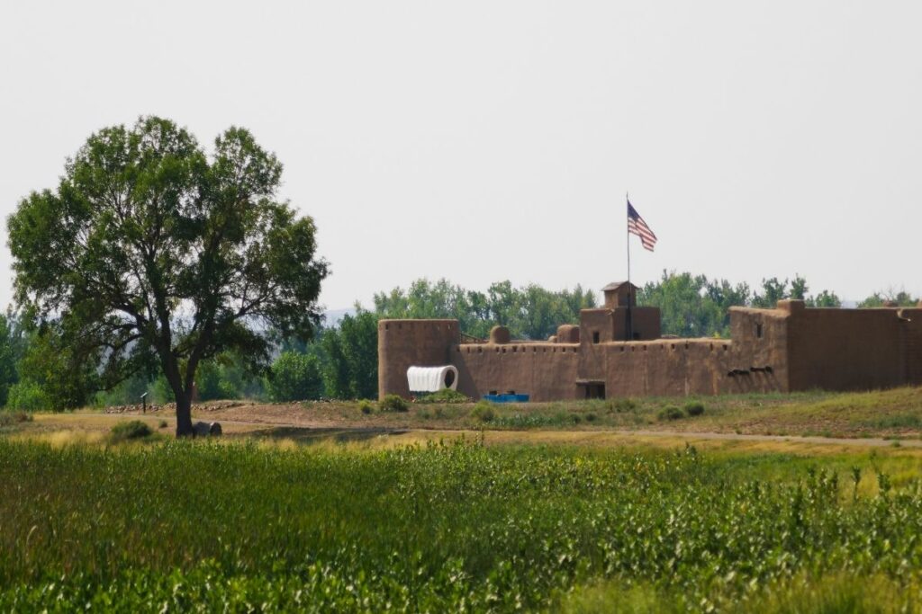
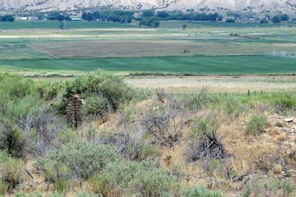
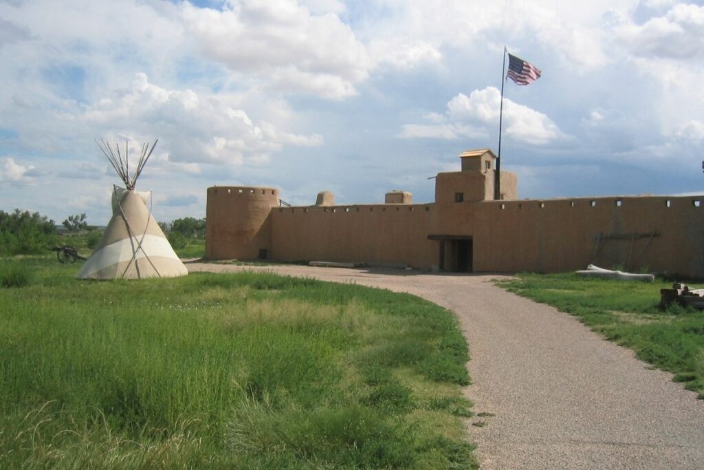
Bent’s Old Fort National Historic Site
The Bent’s Old Fort National Historic Site is a historic commercial hub of the Bent-St. Vrain Company in the 1840s. The fort is located in Otero County and was used by traders, trappers, travelers, and the Cheyenne and Arapaho tribes to gather, barter, and transact.
During its time, it was the only white American settlement that existed along the Santa Fe Trail until it was destroyed in 1849. It was the only settlement that was not controlled by Native Americans or Mexicans in these years. Today, visitors can learn more about the trading empire that stood in the 1800s and view what remained of the last trading cartels in the Rocky Mountain West.
It was established under the care of the National Park Service on June 3, 1960.
Things to do: Hiking, Guided Tours
How to get there: There are commercial airlines to Pueblo and Colorado Springs. By car, travelers can go U.S. Highway 50 and Highway 194. A bus is also available in Rocky Ford, Colorado.
Where to Stay: Bent’s Old Fort doesn’t offer accommodation but the nearest town that offers lodges is La Junta, Colorado. >> Check prices of nearby hotels on Booking.com or Hotels.com
Entrance Fee: $3 per person or free with an America the Beautiful Pass.
Official Website: Click Here
Map: Download
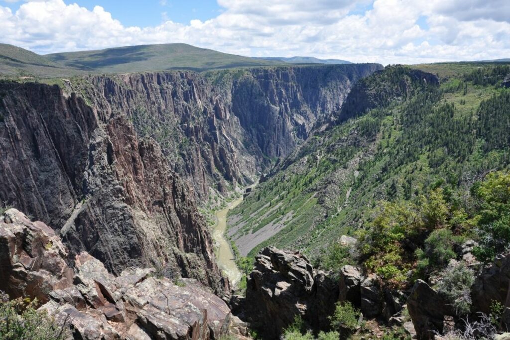
Black Canyon of the Gunnison National Park
Black Canyon of the Gunnison National Park was created by the Gunnison River throughout two million years of erosion and changes. Through that, the Canyon became one of the biggest and deepest cliffs in North America. The park itself is the deepest part of the canyon but the Black Canyon stretches even further than that. This site earned its name because it only receives about thirty-three minutes of sunlight each day. Outside of that time, the canyon feels like it’s pitch black.
Visitors are welcome to enjoy hiking the South and North rims of the canyon. Other activities include scenic views of the old rock formations and the river itself. The gargantuan canyon also allows travelers to enjoy fishing and wildlife watching the diversity available in the park. Pinyon jays frequent the trees of the rim while mule deer can be spotted through the dense bush or even black bears can be seen around the area. Mountain lions, bobcats, and ringtails usually emerge around the park at night.
The Black Canyon of the Gunnison was redesignated as a national park on October 21, 1999.
Things to do: Hiking, Scenic Drives, Fishing
How to get there: The majority of visitors arrive in a private vehicle to reach the park. Montrose, Gunnison, and Grand Junction all have bus and airline services for tourists.
Where to Stay: There is no available lodging in Black Canyon of the Gunnison National Park. Hotels and other accommodation are available in nearby towns like Montrose and Gunnison, Colorado. There are also two campgrounds for an overnight stay in Black Canyon National Park, one on each rim. >> Check prices of nearby hotels on Booking.com or Hotels.com
Entrance Fee: $30 per vehicle or free with an America the Beautiful Pass.
Official Website: Click Here
Map: Download
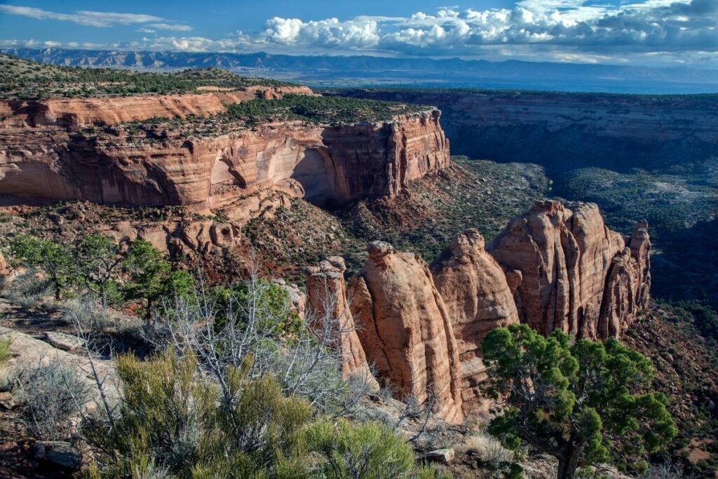
Colorado National Monument
Colorado National Monument preserves a beautiful landscape of the American West. Here, travelers can enjoy the view of enormous monoliths, colors of red and orange throughout the canyon, and a vast plateau.
The park itself is more than 20,000 acres and one of the key features is the Monument Canyon which hosts famous rock formations like the Independence Monument, the Kissing Couple, and Coke Ovens. Travelers also come to this park to enjoy the scenic route of Rim Rock Drive where you have clear views of the rocky canyon and can spot some of the wildlife native to the area like mule deers, coyotes, mountain lions, lizards, and desert bighorn sheep. Regarded as one of the most beautiful drives of the United States, the Rim Rock Drive boasts red and tan rock formations on each side, a picturesque view of the canyon, and many overlooks for drivers to stop and bask the view.
Things to do: Hiking, Bicycling, Rock Climbing
How to get there: Visitors can fly with Allegiant, American Airlines, Delta, and United Airlines. By car, drivers can travel eastbound on Interstate 70 or westbound on Interstate 70. Colorado National Monument has no public transportation, but Grand Valley Transit runs available bus lines throughout the Grand Valley.
Where to Stay: Although there are no restaurants or hotels within the Monument, neighboring towns offer a wide range of dining and lodging options. Fruita, Grand Junction, and Palisade are the nearest towns to the Monument. >> Check prices of nearby hotels on Booking.com or Hotels.com
Entrance Fee: $25 per vehicle or free with an America the Beautiful Pass.
Official Website: Click Here
Map: Download
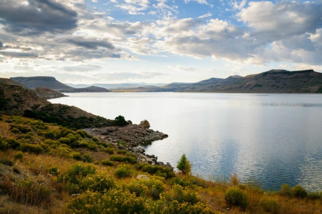
Curecanti National Recreation Area
Curecanti National Recreation Area aims to manage and preserve the three reservoirs along the Gunnison River: Blue Mesa Reservoir, Morrow Point Reservoir, and Crystal Reservoir. Aside from the reservoir, the park has seven trails for hiking and plentiful fish for enthusiasts to catch. The Curencanti boasts deep clear water with lush green mountains and large tan rock formations.
The park has beautiful landscapes for visitors to bask in and explore. This is also a popular destination for tourists to go boating and fishing with Kokanee salmon and lake trout frequenting the waters. Visitors can also opt to go hiking, camping, or bird watching. Other than these outdoor activities, the park has historic relevance to the state with expeditions occurring here, the site of the Wayne N. Aspinall Storage Unit, and the East Portal & the Gunnison Tunnel.
The Curecanti National Recreation Area was established in 1965.
Things to do: Boating, Hiking, Swimming, Horseback Riding
How to get there: In southwest Colorado, you’ll find Curecanti National Recreation Area. The physical address of the recreation area is 102 Elk Creek, Gunnison, Colorado. The area can be accessed from Colorado Highway 149 and 92. Within the recreation area, public transit is not available. Gunnison and Montrose both have bus and airline services.
Where to Stay: Curecanti includes ten campgrounds for tents and RVs with a variety of amenities. Gunnison, CO is nearby and has some lodging options. >> Check prices of nearby hotels on Booking.com or Hotels.com
Entrance Fee: Free
Official Website: Click Here
Map: Download
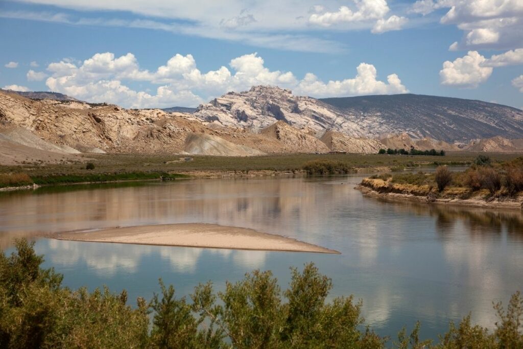
Dinosaur National Monument
The Dinosaur National Monument is shared by both states of Utah and Colorado and what was once the unexplored Yampa River Canyon. These picturesque rock formations are located just southeast of the Uinta Mountains. Famous for the Dinosaur Quarry, many fossils and remains of prehistoric eras can be found in the monument.
The first discovery was the eight vertebrae of an Apatosaurus that was excavated by paleontologist Earl Douglass of the Carnegie Museum. The subsequent excavations found other fossils embedded in the different rock formations in the area like a dinosaur skull or even petroglyphs. The monument also offers other fun outdoor activities for visitors like river rafting and horseback riding.
This area was officially established as a national monument in 1938.
Things to do: River Rafting, Picnicking, Camping, Hiking
How to get there: Both Colorado and Utah are connected to Dinosaur National Monument. Each state offers visitors the opportunity to see the monument uniquely. The monument’s east side, Colorado, provides access to steep valleys along the Green and Yampa rivers. The Canyon Visitor Center is located just off U.S. Highway 40, two miles east of Dinosaur, CO.
Where to Stay: Dinosaur National Monument does not have any lodging or hotels. Vernal, UT, and Dinosaur, CO, are nearby towns with lodging. >> Check prices of nearby hotels on Booking.com or Hotels.com
Entrance Fee: $25 per vehicle or free with an America the Beautiful Pass.
Official Website: Click Here
Map: Download
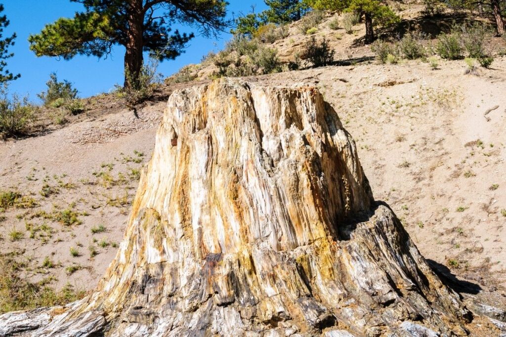
Florissant Fossil Beds National Monument
The Florissant Fossil Beds National Monument is one of the richest fossil deposits in the world. Located in Teller County, this sedimentary geological formation holds many fossilized creatures from the Eocene era. This national monument offers a glimpse for today’s researchers, enthusiasts, and tourists of what life in the Palaeolithic era looked like. One of the key features is the Petrified Forest, which had many fossilized stumps from the prehistoric era. Unfortunately, many have been lost through years of the public taking petrified wood from the area.
These fossils have been dated to be at least 34 million years old and have stood the test of time. This is believed to be possible because of the interaction of the lake and the volcanic ash from the nearby Thirtynine Mile volcanic field.
Aside from the large deposit of fossils, this monument also includes the Hornbek Homestead nearby which is one of the first woman-owned ranches in the area.
The Florissant Fossil Bed National Monument was established in 1969 after a battle between local owners and the federal state. Now, the National Park Service is committed to protecting this land and its geological and historic relevance.
Things to do: Picnicking, Hiking
How to get there: By plane, Colorado Springs International Airport is the closest to the Monument. Visitors traveling north or south on I-25 should exit at US 24 West and travel 35 miles to Florissant, then two miles south to the visitor center on Teller County 1.
Where to Stay: Florissant Fossil Beds National Monument does not have any lodging, campsites, or restaurants. Woodland Park, Cripple Creek, and Colorado Springs are the closest towns with hotels. >> Check prices of nearby hotels on Booking.com or Hotels.com
Entrance Fee: $10 per person or free with an America the Beautiful Pass.
Official Website: Click Here
Map: Download
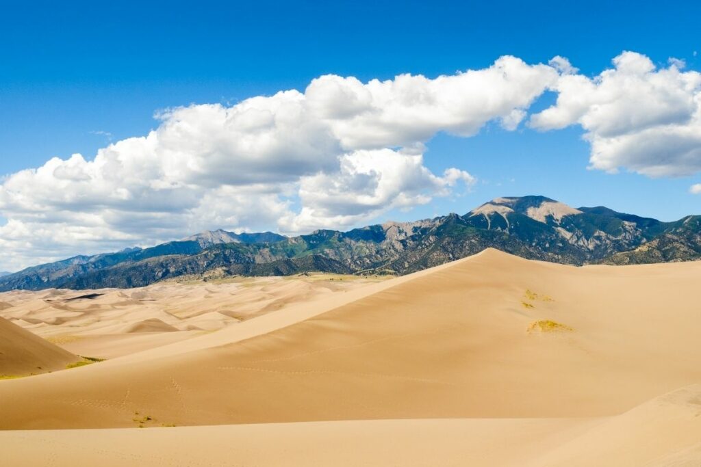
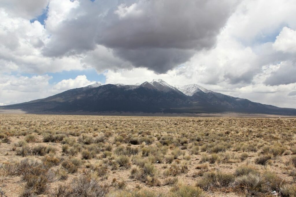
Great Sand Dunes National Park and Preserve
In an area in the San Luis Valley, lies many sand dunes up to 750 feet tall. The National Park Service aims to preserve these sand dunes and established the Great Sand Dunes National Park and Preserve. It is the largest collection of sand dunes in the United States and covers an area of about 32 square miles. It sits in beautiful contrast against lush green grasslands, diverse wetlands, and tundra.
Throughout history, there is evidence of settlers in the area from as far as 11,000 years ago. It is believed that hunters and gatherers from the prehistoric era have a connection to the area. The earliest settlement that has been discovered is ancient native tribes.
Visitors frequent the area for fishing, hunting, hiking, horseback riding, and of course, enjoying the sand. Aside from hiking the dunes, visitors can try sandboarding and sand sledding. Other sites in the area are the Medano Creek which is a seasonal stream visitors can enjoy.
Things to do: Photography, Sandboarding, Fishing, Hiking
How to get there: A small airport in Alamosa, Colorado, 38 miles from Great Sand Dunes, has acommercial air service. Many commercial airlines fly to Colorado Springs, Denver, and Albuquerque. The most common route by car is I-25 south to Walsenburg.
Where to Stay: Within the national park or preserve, there are no accommodation choices. In Mosca, Rustic Rook, and Alamosa, are near area communities that offer hotels, inns, and motels. >> Check prices of nearby hotels on Booking.com or Hotels.com
Entrance Fee: $25 per vehicle or free with an America the Beautiful Pass.
Official Website: Click Here
Map: Download
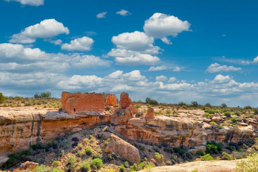
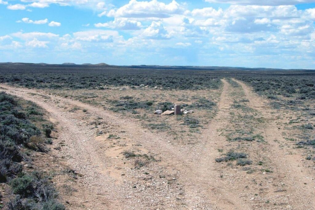
Hovenweep National Monument
Hovenweep National Monument aims to preserve the history and legacy of the ancient people that lived here in the 12th century. In the monument, visitors can find the original stone and masonry of different buildings created by the Puebloan people.
The 784 acre area full of buildings is divided into six different groups: the Cajon Group, Cutthroat Castle group, The Holly group, Hackberry group, Horseshoe group, and the Square Tower group. Here, travelers can see the great talent of the Puebloan people as their creations stood the test of time and now offers a glimpse of life in that era. There are still remnants of different houses, towers, and even castles.
Hovenweep became a National Monument in 1923 and is now under the care of the National Park Service.
Things to do: Stargazing, Bird Watching, Hiking
How to get there: Travelers can fly to Cortez, Durango, Grand Junction, Colorado; Salt Lake City and Moab, Utah; and Albuquerque by commercial airlines. Drive to US 491 south of Cortez for 30 miles by car and following County Road G / McElmo Canyon Road. Nearby towns that served commercial bus and van shuttles, but they do not go directly to Hovenweep.
Where to Stay: Hovenweep National Monument has no restaurants or lodgings. Monticello, Blanding, and Bluff, Utah, as well as Cortez, Colorado, are the closest restaurants and hotels. Hovenweep is around 40-45 miles (one hour) away from these towns. >> Check prices of nearby hotels on Booking.com or Hotels.com
Entrance Fee: Free
Official Website: Click Here
Map: Download
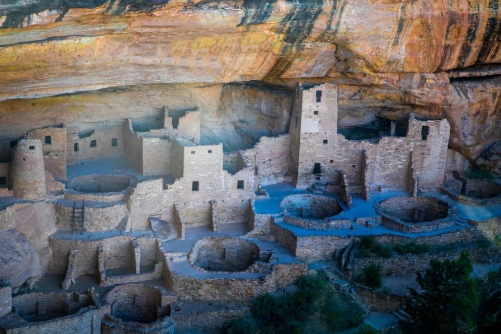
Mesa Verde National Park
Mesa Verde National Park preserves over 52,000 acres of cliffs in Montezuma County, Colorado. Now a UNESCO world heritage site, this park maintains the legacy of the Ancestral Puebloan people that lived between 550 to 1300 CE. They have built thriving communities in the area and thrived here for more than 700 years.
Today, visitors can see many archaeological remains of twenty-six tribes like pithouses, pueblos, masonry towers, and farming structures. One of the key features to be visited is the cliff dwellings that the Puebloan people built on the overhanging sides of the cliffs in the area. These outstanding structures range from one-bedroom creations to more outstanding and complex structures. Atop the site, travelers can even find remnants of towers and a sun temple. These ancient stones provide a unique window to the past of the Puebloan people before they migrated to New Mexico and Arizona.
President Theodore Roosevelt approved the park in 1906 to “preserve the work of man.”
Things to do: Camping, Stargazing, Hiking
How to get there: Getting There by Car The Mesa Verde Headquarters and Chapin Mesa area is a one-hour journey east on Highway 160 to the park turnoff from Cortez, Colorado. It takes 1.5 hours to drive from Durango, Colorado, to the park turnoff on Highway 160 west. Cortez, Colorado; Durango, Colorado; and Farmington, New Mexico are the closest airports.
Where to Stay: There is a lodge within the area. Far View Lodge is located 15 miles from the park entrance and just six miles from the Chapin Mesa Archeological Museum and the Spruce Tree House cliff dwelling. >> Check prices of nearby hotels on Booking.com or Hotels.com
Entrance Fee: $30 per vehicle or free with an America the Beautiful Pass.
Official Website: Click Here
Map: Download
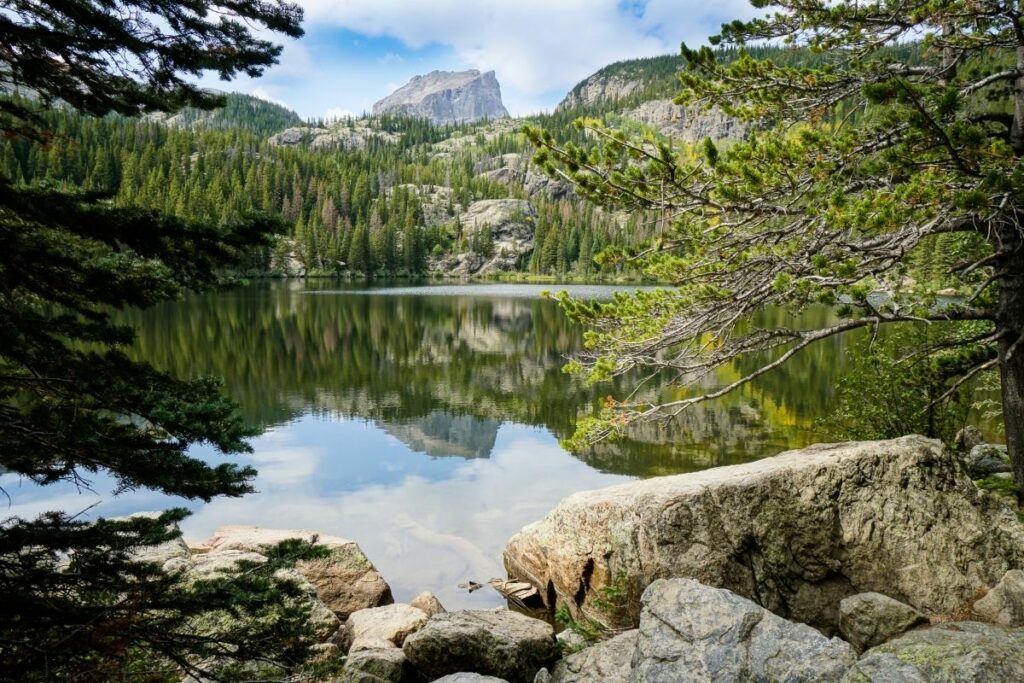
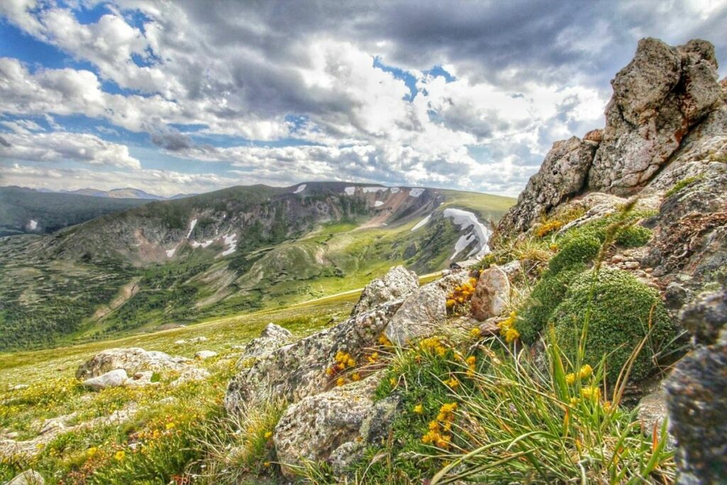
Rocky Mountain National Park
Rocky Mountain National Park is within the front range of the Rocky Mountains in Colorado. This park has been ranked the third most visited national park in 2015 and for great reason. The park boasts some of the most picturesque views with alpine lakes, lush wooded forests, and a view of the gargantuan mountain tundra of the Rocky Mountains.
The park is famous for its natural wonders wherein visitors often hike around the area to enjoy the breathtaking views and get a glimpse of the wealth of wildlife in the area. There are rare instances that you can still spot some endangered species like the Canada Lynx, the Mexican Spotted Owl, or the North American Wolverine. Other more common wildlife that thrives in the area is different amphibians, bird species, and small mammals like beavers, bighorn sheep, black bears, elks, pikas, mule deer, mountain lions, and more. There is so much more to discover when exploring the beautiful forests and mountains of this park.
Things to do: Hiking, Backpacking, Scenic Drives, Wildlife Watching, Camping, Picnicking
How to get there: The nearest major airport is Denver International Airport (DEN). The Boulder/Hwy 36, Hwy 66, and Peak to Peak Scenic By-way are all options for drivers. There is no public transit to the park’s east or west sides from the Denver region.
Where to Stay: There are no overnight lodgings at Rocky Mountain National Park, unlike several other national parks. The surrounding towns of Estes Park and Grand Lake provide a variety of hotel choices. There are, however, five developed campgrounds, four of which are open to tent or vehicle camping, and one of which is just for tent campers. >> Check prices of nearby hotels on Booking.com or Hotels.com
Entrance Fee: $35 per vehicle or free with an America the Beautiful Pass.
Official Website: Click Here
Map: Download
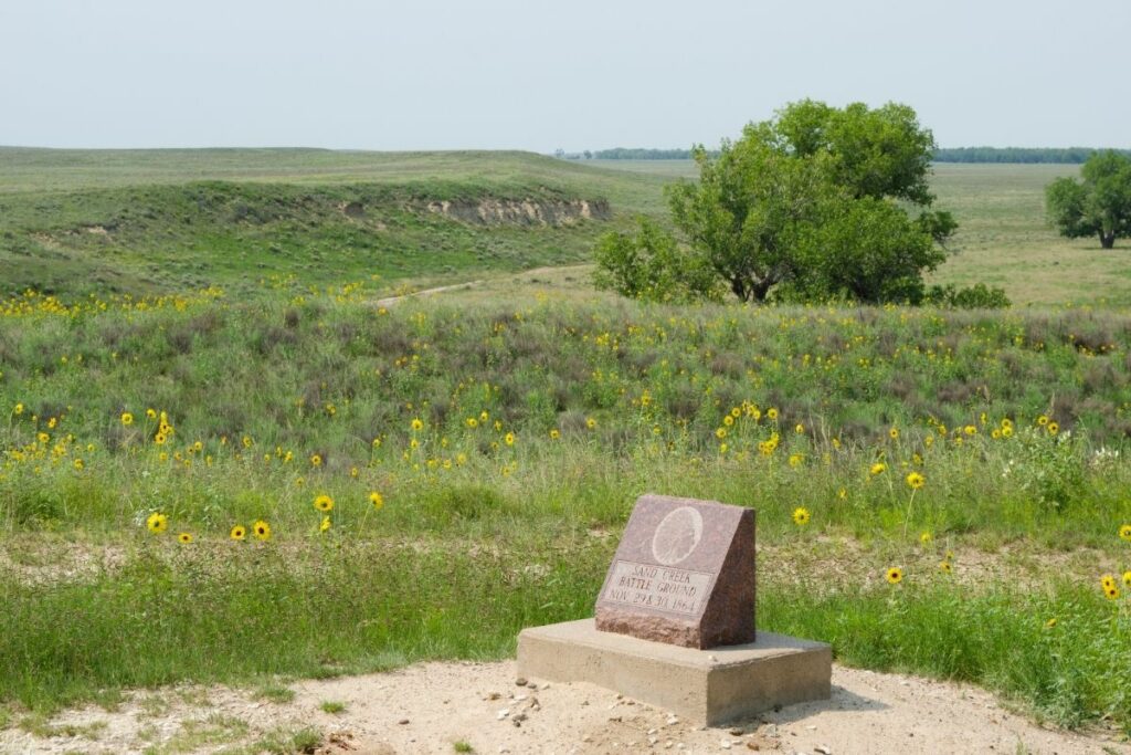
Sand Creek Massacre National Historic Site
Located in Kiowa County, Colorado, the Sand Creek Massacre National Historic Site commemorates a more grim memory of the state. The Sand Creek Massacre happened here on November 29, 1864. The massacre was the death of many of the Cheyenne and Arapaho people by the U.S. Army during the American Indian Wars.
The American Indian Wars was the struggle between European and later on American and Canadian colonists and Native American tribes over colonies in the United States. On that fateful day of 1864, Colonel John Chivington ordered 675 of his cavalrymen to attack this native tribe. An estimated 70-500 Native Americans were killed in this event with many being women or children which marked and changed the Great Plains forever.
The Sand Creek Massacre National Historic Site was established on April 28, 2007, and preserves the legacy and history of the tribes that have lost their lives in the massacre.
Things to do: Bird Watching, Hiking, Learn about the Massacre from an interpretive ranger.
How to get there: Drivers can travel 2.7 miles south on Highway 287, then turn left onto Highway 96 East. Continue through Chivington until you reach Chief White Antelope Way. For about 8 miles, turn north on Chief White Antelope Way. Between Sand Creek Massacre NHS and the surrounding communities, there is currently no public transportation.
Where to Stay: Lodging is not available in the Sand Creek itself but there are options in Lowell which is only 14 miles away, visitors can tend to stay overnight. >> Check prices of nearby hotels on Booking.com or Hotels.com
Entrance Fee: Free
Official Website: Click Here
Map: Download
Yucca House National Monument
Yucca House National Monument preserves one of the largest archeological treasures in the United States. Located in Montezuma County, Colorado, tourists and researchers can enjoy the wealth of this beautiful unexcavated Ancestral Puebloan archaeological site.
Once occupied by about 13,000 people, this monument hosts many tribes of the Puebloan people between AD 1100 and 1300 before migrating to other areas. While most of the site remains untouched, it is believed to have the ruins of 600 rooms, 100 kivas, several towers, multiple plazas, unexplained structures, and one great kiva beneath the exposed land. This 34-acre land was an integral community of the Puebloan people and it got its name with the plethora of yucca growing in the area. Aside from yucca, the valley has a variety of wildlife. Originally called the “Aztec Springs” to remember the spring that still exists in the area creates ideal habitats for a plethora of species to thrive here. There have been sightings of 6 amphibian, 125 bird, 69 mammal, and 19 reptile species so far but discovery is still ongoing.
Yucca House was officially named as a national monument in 1919.
Things to do: Nature sightseeing
How to get there: In a vehicle, There are currently no signs pointing you in the direction of Yucca House. The private property surrounds the monument. The route to Yucca House turns to gravel or dirt once you leave the main highway, and it may be difficult in bad weather. But drivers can take the route 160 West through Cortez, to Hwy. 491 South. You can fly into Cortez, Colorado, which is the nearest airport. Yucca House is not accessible by public transit.
Where to Stay: Although there are no restaurants or hotels within the Monument, neighboring towns offer a wide range of dining and lodging options. Cortez is the nearest town to the Monument. >> Check prices of nearby hotels on Booking.com or Hotels.com
Entrance Fee: Free
Official Website: Click Here
Map: Download
Associated Sites of Colorado
California National Historic Trail
The California National Historic Trail preserves the largest migration in the history of the United States. It remembers the event wherein 250,000 emigrants from different states made their way westward to the promise of new land and fortune, California.
California was once a forgotten area because it was not easily accessible. The only way to reach the area was to travel by sea or go through treacherous pathways across different states. The first group that braved this journey was from Missouri. Their journey left many hungry, sick, and even naked. However, they were successful. Through their feat, many groups followed suit and that multiplied when thoughts of fortune during the California Gold Rush circled throughout different communities.
Today, this destination is perfect for hikers to follow the footsteps of the brave people that traveled for a better life and traversed the difficult roads on some of the still existing trail segments. Unfortunately, most of the segments of this trail are now privately owned or restricted. However, there are some segments open for the public for hiking and other outdoor activities.
Things to do: Auto-touring, Visiting Sites, Hiking, Bicycling, Horseback Riding, Visiting Museums
How to get there: Nearly 2,000 miles of historic trail were once the primary “road” used by farmers, enterprising business managers, gold-seekers, and fortune hunters who chose to make a new life on the California frontier and those portions of the California National Historic Trail authorized by Congress include them. From Missouri to California, the path passes across ten states.
Where to Stay: There are various lodging areas around the California National Historic Trail. Travelers can choose from 10 different states to visit and enjoy.
Entrance Fee: Free but various attractions along the trail may charge an entrance fee.
Official Website: Click Here
Map: Download
Old Spanish National Historic Trail
The Old Spanish National Historic Trail stretches across six different states: New Mexico, Colorado, Utah, Arizona, Nevada, and California. It preserves the thriving commercial trade that occurred in the 1700s between Los Angeles and New Mexico. This trail was named after the many Spaniards that used this trail during the trading boom of that era. It was first named this in a report by John C. Frémont of his 1844 journey for the U.S. Topographical Corps.
During the 1700s, many would use this pathway to move and trade horses and mules around the area. It wouldn’t be uncommon for people to transport contraband goods or even Indian Slaves across the trail.
This trail was included in the National Trail Systems in 2002.
Things to do: Public lands and state, county, and city parks along the trail route preserve trail resources and provide for recreation activities.
How to get there: Flying into the state using a variety of airports, including Santa Fe, New Mexico; Alamosa and Durango, Colorado; Las Vegas, Nevada; St. George, Utah; Flagstaff, Arizona; and Los Angeles, California, will get you to the national historic trail. These cities are well-connected to trail-related destinations.
Where to Stay: Travelers can visit Arizona, California, Colorado, Nevada, New Mexico, and Utah, with countless lodging, hotels, and inns available in those states.
Entrance Fee: Free but various attractions along the trail may charge an entrance fee.
Official Website: Click Here
Map: Download
Pony Express National Historic Trail
Sending parcels and quick delivery of mail and letters have been increasingly more important in the 1800s especially with the California Gold Rush, suddenly there was an influx of prominence and people that moved to this area. A company decided to capitalize on this interest and created a fast route for mail. Owned and operated by Central Overland California and Pikes Peak Express Company. Pony Express was born. Pony Express National Historic Trail preserves the route of these speedy parcels that young men can ride horseback and deliver within ten days!
While difficult to believe now with the dawn of instant messaging and the digital age, Pony Express revolutionized mail. The Pony Express could deliver letters faster than ever before as they cross the 1800-mile-long trail to deliver their speedy service. With their success, they made it clear that there was a new need for people to get their parcels earlier. After some time, Congress authorized to subsidize a transcontinental pathway for these parcels. After this pathway was established, the Pony Express seized operations but will forever be remembered in the Old West.
Today, travelers can visit museums to learn more about the Old West, try their hands at horseback riding, hike the trail and enjoy the views.
Things to do: Auto Tours, Hiking, Bicycling, Horseback Riding, Visiting Museums
How to get there: One of the trail segments crosses Julesburg or Ovid, Colorado. It is best to travel the trail via car and explore the different towns on the way. The nearest airports are Western Nebraska Regional Airport and North Platte Regional Airport.
Where to Stay: Depending on where you stop, you can expect a wide array of lodging or campgrounds available in each of the towns near or along the trail
Entrance Fee: Free but various attractions along the trail may charge an entrance fee.
Official Website: Click Here
Map: Download
Santa Fe National Historic Trail
Santa Fe National Historic Trail preserves one of the most important trails in American history. Known as the Great Prairie Highway, this trail connects five states from Missouri all the way to New Mexico. This became an integral enabler for trade and communication during the 1800s.
Stretching 1200 miles long, this is one of America’s great trading routes. First spearheaded by William Becknel, the path became increasingly more important for traders and commerce. Realizing the value, the Comanche started to demand a fee for granting passage of the trail. This caused a major disruption in bison habitats and trade. Eventually, the species collapsed and the Comanche power declined in the region when they lost this steady supply of bison.
Aside from trade to Mexico City, the area has also been integral during the Civil War and the Mexican-American War. Today, only sections of the Sante Fe Trail exist and is open to the public.
Visitors can travel back in time and learn about the thriving business that occurred in the area all those years ago and bask in the beautiful views of the trail.
Things to do: Hiking, Visit Landmarks, View Santa Fe Trail Ruts, Visit Museums
How to get there: By plane, visitors can fly in through the different airports in Denver, Colorado Springs, and Pueblo, Colorado. The mountain route in Colorado can be found near Lamar. Drivers can take US-50 (Eastern Colorado) and US-350 (Southern Colorado) to experience the trail itself by car.
Where to Stay: Depending on the state, there are many options for lodging along and around the trail. Some nearby towns from the trail are Lamar, Las Animas, La Junta, and Trinidad, Colorado.
Entrance Fee: Free but various attractions along the trail may charge an entrance fee.
Official Website: Click Here
Map: Download
List of National Parks in Colorado
There are 13 National Parks in Colorado that received 6 million visitors in 2020 and generated over $586 million in tourism economic benefits. The majority of visitors (3.3 million) visited Rocky Mountain National Park..
- Bent’s Old Fort National Historic Site
- Black Canyon of the Gunnison National Park
- Colorado National Monument
- Curecanti National Recreation Area
- Dinosaur National Monument (CO, UT)
- Florissant Fossil Beds National Monument
- Great Sand Dunes National Park
- Great Sand Dunes National Preserve
- Hovenweep National Monument (CO, UT)
- Mesa Verde National Park
- Rocky Mountain National Park
- Sand Creek Massacre National Historic Site
- Yucca House National Monument
Affiliated Areas
- California National Historic Trail (CA, CO, ID, KS, MO, NE, NV, OR, UT, WY)
- Old Spanish National Historic Trail (AZ, CA, CO, NV, NM, UT)
- Pony Express National Historic Trail (CA, CO, KS, MO, NE, NV, UT, WY)
- Santa Fe National Historic Trail (CO, KS, MO, NM, OK)
Colorado National Parks also provides support and management for 3 National Heritage Areas, 1 Wild and Scenic River as well as 1,597 National Register of Historic Places Listings.
There are 25 National Historic Landmarks, 16 National Natural Landmarks, 931 Places recorded by the Heritage Documentation Program and over 6.38 million objects in the Colorado National Parks Museum Collections. There are 7,397 Archaeological Sites in the Colorado National Parks.
Colorado is home to 42 State Parks.
Colorado UNESCO World Heritage Sites
- Mesa Verde National Park
Colorado’s Neighboring States
Planning to visit a few of the National Parks of Colorado and wandering about what national parks are in neighboring states. Here are the list of National Parks in surrounding states.
- Arizona National Parks – Arizona is home to Grand Canyon, Petrified Forest and Saguaro National Parks and 19 NPS units.
- Kansas National Parks – Kansas has 5 NPS units.
- Nebraska National Parks – Nebraska has 5 NPS units.
- New Mexico National Parks – New Mexico is home to Carlsbad Caverns and White Sands National Park along with 13 other units.
- Oklahoma National Parks – Oklahoma has 3 NPS units.
- Utah National Parks – Utah is home to the Mighty Five National Parks (Arches, Bryce Canyon, Canyonlands, Capitol Reef, Zion) and 8 NPS units.
- Wyoming National Parks – Wyoming has 2 National Parks: Grand Teton National Park and shares Yellowstone National Park with Montana and Idaho plus 5 NPS units.
Final Thoughts of the National Parks in Colorado
I hope this guide to the National Parks in Colorado is helpful as you plan to explore these amazing National Parks.
Pin for Later: National Parks in Colorado: Explore the 13 Colorado National Parks (2021 Update)

Hi, I'm Jennifer!

Welcome to the wonderful world of National Parks. I'm here to help you plan your NEXT amazing adventure through the United States National Parks and beyond. I want the national parks to be accessible to all.
I live in Tennessee, and when I'm home, you can find me hiking in the Smokies and the Cumberland Plateau.
58/63 National Parks
250+/423 National Park Units
Want to know more? Start Here.
Snag one of my National Park Ebooks and Downloadable Itineraries

Talk with an Expert

Share your love of the parks with a shirt, ornaments, hoodies, frames, and more.
